
Inside the Flood Fight, Part 2: Spring Conditions Prompt Action
After a winter of monitoring moisture conditions and preparing as much as possible [see Part 1], area water experts have a pretty decent idea whether there is reason for concern when the spring melt begins. This edition of Inside the Flood Fight, part two of three, explains how Moore’s water resources engineers experts go to work when conditions seem ripe for a flood event.
Water Level Gauges Play Key Role
Our water resources engineers work with our clients – water resource districts, cities, counties and more – to be proactive when a flood seems imminent. The U.S. Geological Survey has a series of year-round water level gauges set up across the area, which transmit data automatically so it is accessible to all online. Our experts scour these reports, along with those of the National Weather Service, to gain as much knowledge as possible regarding the likelihood and severity of a flood event.
Flood models created by the National Weather Service tell our engineers where water is a threat and to what extent. Flood events are chaotic and often unpredictable, because there are so many variables and no one knows what Mother Nature has in store for us. We can track some variables, though, like the speed of the snowmelt, the location of snowpack, additional precipitation, the river’s flow rate and many other factors.
In addition to the U.S. Geological Survey’s gauges, Moore sets up its own lower tech gauges at strategic locations to monitor change in water level. These gauges are simply physical markers that must be read manually. Moore employees make dozens of trips to gauge sites across the countryside to keep abreast of water levels. Seven days a week during flood season, they monitor where water is and how high it is getting.
“When we know a flood is coming, we have an organizational meeting where we map out employee availability,” says Mike Opat, Moore water resources project manager. “It’s an all-hands-on-deck situation where we ensure everything is covered the way it needs to be. We schedule people to check gauges, visually inspect conditions by land and air, and monitor sites like dams and drains.”
Key Advisors
“During a flood event, we’re in constant communication with our clients, ensuring they understand the facts on the ground in their jurisdiction,” says Opat. “They depend on us to keep them informed about what is happening and what is likely to happen.”
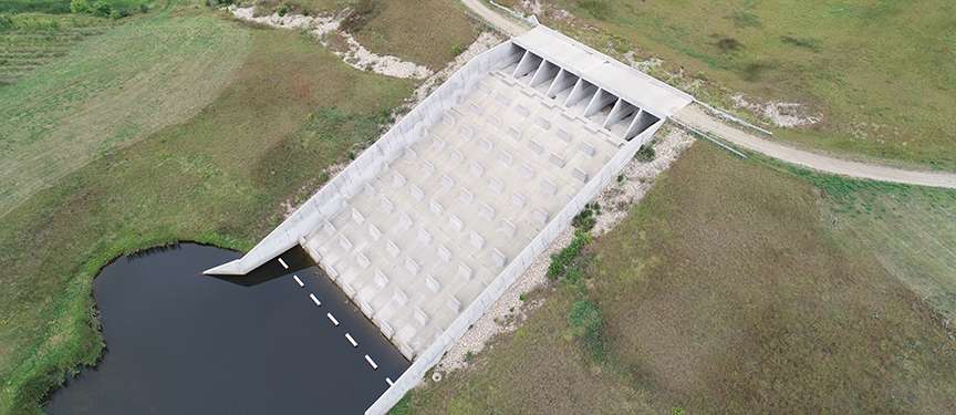
 Moore, for example, works with the Cass County Joint Water Resource District, which owns and operates the Maple River Dam. Moore monitors the dam to ensure it is operating properly, storing water until the reservoir fills and water eventually begins flowing over the spillway. That is a dramatic moment for Moore’s engineers, area landowners and water resource district board members, mostly because it happens so infrequently.
This year, there has been a tremendous amount of overland flooding in addition to overflowing rivers. Moore is increasingly using drone technology to monitor conditions from the air, in addition to traditional observation from an airplane. The aerial perspective is key in helping decision makers and property owners understand which roads, bridges and farm properties are in danger.
“We have a lot of cumulative experience with eastern North Dakota flood events,” says Opat. “Visual inspection by air is invaluable in helping ensure property and infrastructure is protected. Water resource districts cover wide geographic areas, so while dams are of primary importance because of their potential impact, we need to consider everything in a water district’s jurisdiction and advise the board accordingly.”
Which areas might need sandbags? Which roads are going to become inundated? Which road crossings are susceptible to failure? Which farmyards are at risk? When will the water subside? And will there be a second crest? These are just some of the questions Moore’s engineers help answer, providing guidance in the midst of many unknowns and continually changing conditions during a flood event.
We explore this topic in Part 3 of our Inside the Flood Fight series: Many Variables Make Flexibility Key.